
Tuesday, October 18, 2011
Friday, October 14, 2011
Geiger Counter Kit

Introducing the Geiger Counter Kit from the Maker Shed. This kit costs a fraction of a commercial unit and it works just like you it should, blinking and clicking in the presence of radiation. It takes about an hour to build and even has a serial output for tracking radioactivity over time.
Is Grandma’s pottery or glass collection radioactive? Do bananas give off radiation? Is that granite table given to you by your mother-in-law slightly “hot?” (In my case, yes!) With this Geiger Counter Kit these questions are yours to answer. While this is a functional Geiger counter it is for educational purposes only. Please do not use it for anything important.
Saturday, October 8, 2011

Thursday, October 6, 2011
Good bye Mr.Steve

"Because the people who are crazy enough to think they can change the world, are the ones who do."
Monday, October 3, 2011
Submarine cable system connecting the world

TeleGeography’s free interactive submarine cable map is based on our authoritative Global Bandwidth research, and depicts 188 active and planned submarine cable systems and their landing stations. Selecting a cable route on the map provides access to data about the cable, including the cable’s name, ready-for-service (RFS) date, length, owners, website, and landing points. Selecting a landing point provides a list of all submarine cables landing at that station. more
Sunday, October 2, 2011
Google Maps Feature Lets You 'Helicopter' Preview Routes
Google Maps now includes a cool new feature that lets you preview a route with a 3D bird's eye animation, whether you’re driving, walking, biking, or using mass transit.
To use it, go to Google Maps, click "Get directions," and input your start and end points—just like you would normally. Starting Friday Google has added a small "3D" button next to "Driving directions to (your destination)."
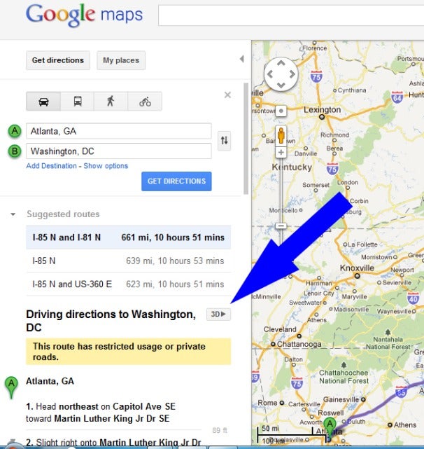
Click on it and your once two-dimensional route comes to life in Google’s Web-based version of Google Earth. Now views allow you to see 3D rendering of elevations such as buildings, hills and mountains as Google flies you along your recommended route.
You can pause the flight by clicking anywhere in the 3D view or on the pause button in the lower left of the map. While the flight is paused, you can explore the surrounding area in 3D by clicking and dragging the map.
For instance, you could take a break from your helicopter ride and click on photos, YouTube videos or Wikipedia pages that are geo-linked to locations along your route.

To resume the flight, you just click on the play button in the lower left of your map.
If you’re not sure which leg of the trip you’re seeing, just look to the left panel where it is highlighted in the directions. You can also use this pane to fast forward or reverse your virtual trip by clicking on a different step.
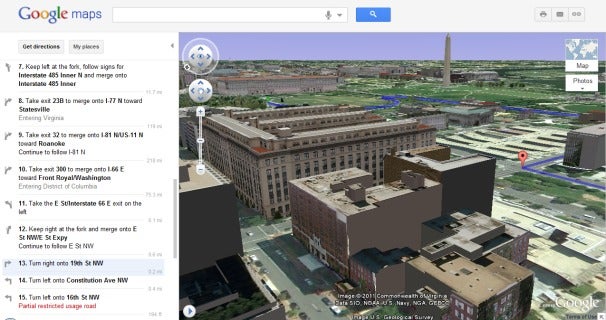
If the images here -- captured from a virtual trip from Atlanta to Washington, D.C. -- don’t impress you, check out the blog post from Google’s Earth and Maps team where they show photos from a picturesque drive from Carmel, California to Big Sur.
Either that, or play around with it yourself -- maybe taking a pretend trip from London to Paris, or Beijing to Shanghai. read more
Subscribe to:
Posts (Atom)